Establishing a geographical information system for effective control of public lighting maintenance and management operations and fountain terminals in Gabon/Identification and training of staff, creation of a GIS service, development of a strategy for the collection, processing and production of public lighting data. Development of a GIS platform to collect and share SIGCNEE data. Detailed activities that have been completed:
Existing Analysis
Establish an operational SIG cell (Staff identification, training, equipment acquisition, and software solutions)
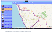
Gather public lighting data with GPS cameras in the field
IMIS Database Development
An information system about the city of Libreville exists and is regularly updated by the service created
A scientific presentation presented at SAGEO 2012 in Liege, Belgium
A presentation presented at Esri 2013, California, USA.
Write user manuals.